|
Download Plotter Planner Plus
Portfolio of Charts
Purchase
Planner Plus
Outline Planner
C-Map Planner
Tides, Streams & Wrecks
Tides and Tidal Streams
Tides
Site Map
Contact
Order
Terms and Conditions
Privacy
Home Page
Plotter Planner PLUS £95.00
Includes one UKHO portfolio of charts
Additional Portfolio of Charts £29.00
each
Plotter Planner PLUS £195.00
Including the full set of portfolio of charts
Plotter Planner PLUS
£141.00 includes one Imray folio of
charts
Additional Imray folio of charts
£75.00 each
|
Tidal Passage Planning and Online
Navigation Program
Course Calculations from Tides, Tidal Streams and Grib Wind data
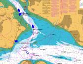
Click for larger image images
Plotter Planner
PLUS
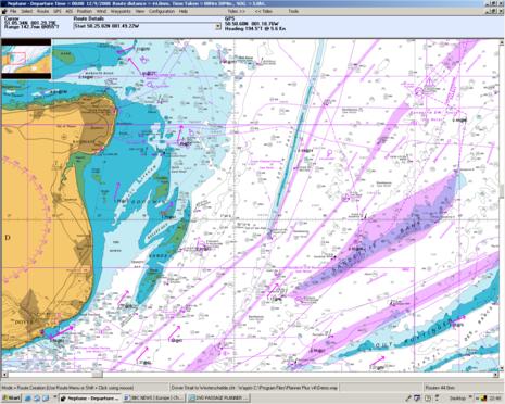
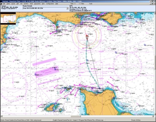
This tidal passage planning and navigation program using Neptune's
established algorithms calculating course to steer, course over ground
and optimised departure times all taking into account tides and tidal
streams from inbuilt tidal data. After a calculation the results are
readily available on screen with the vector plot construction shown so
that navigators can cross check their chartwork.
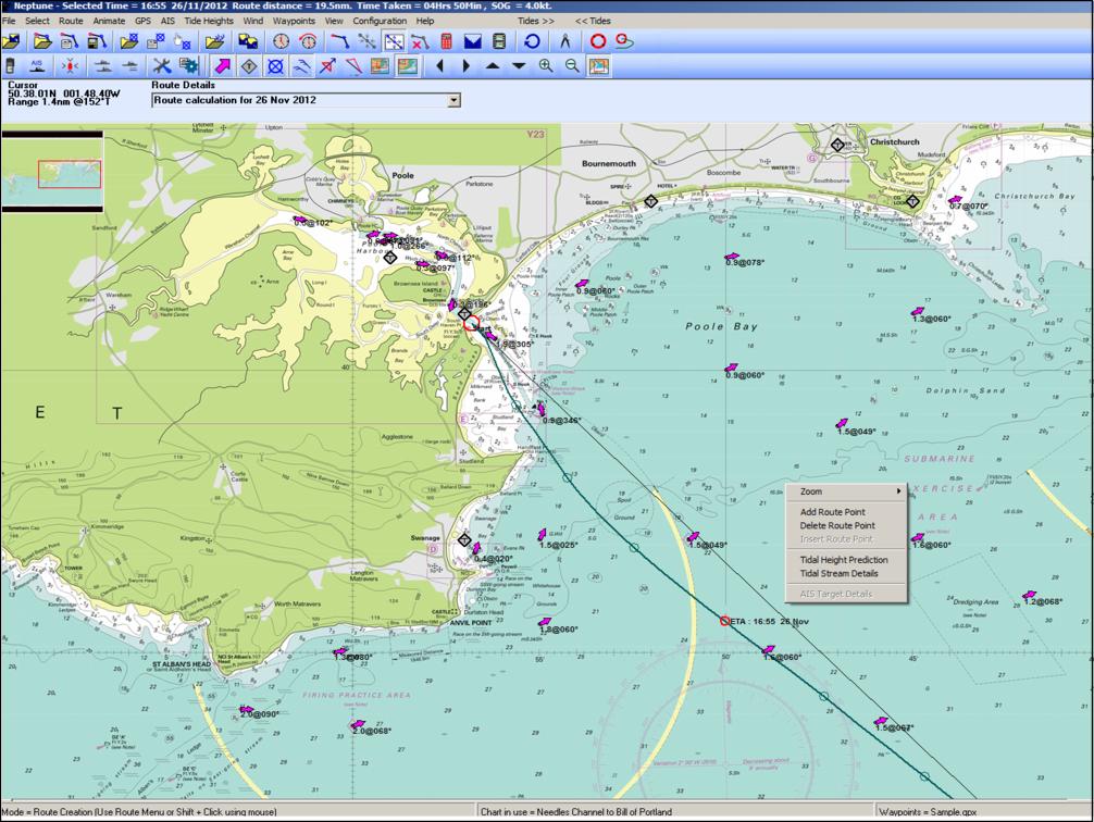
Once a route has been set-up you can use the tide roll function to see
the effects of different departure times on the course to steer and the
effects of course over ground. Also the program allows the navigator to
view the tidal conditions from 3 to 30 minute intervals in the journey.
The cartography used in this software is reproduced from the raster
chart data supplied by the UK Hydrographic Office this including
planning, pilotage, rivers and harbours charts.
The program interfaces to AIS and GPS receivers and uniquely produces a
predicted track plot for the target vessel taking into account tides.
Connected to a GPS the programs will act as a plotter and at the same
time allow you some very flexible waypoint management between PC and
GPS. If you do not connect a GPS to the PC you can plot in manual mode.
Waypoint files can be created either by typing in the co-ordinates and
names or by simply pointing and clicking with your mouse, you can keep &
edit many waypoint files on your PC and call them up at the click of a
mouse. Routes can be saved and edited on screen.
If you are interested in the effects of wind, Neptune Planner PLUS
allows you to overlay wind direction onto passage plans and will
show your no sail area, making it instantly visible if a plan can be
sailed for the prevailing conditions. Download Grib files from the
internet and the wind element will be taken into account when
calculating routes, so enabling prediction of boat speeds and routes to
be planned with better precision.
For those interested in boat performance then Polar Plots and boat speed
estimation routines for the wind conditions are built into the software.
The programs output is easily copied to the clipboard for pasting into
the passage plan for SOLAS purposes.
After any calculation where Course Over Ground (COG) is being predicted,
an animate menu is visible. Showing the expected boat position, tidal
streams and valid wind Grib file, for ever 15 minutes of your route.
The program includes ports tidal height predictions displaying the daily
curve, instantaneous rate of rise or fall of the tide (in metres per
hour), sun rise and set times, lunar phases, springs to neaps indicator,
monthly tide times and heights.
You can plan into the future or re-visit last years calculations as you
wish. There are many features that can be explored. The program is not
time limited, and so no yearly updates are required. However the charts
can be annually updated.
This remarkably easy to use software is full of invaluable features for
the sailor, racer, power boater, diver and fisherman.
System
requirements:
Recommended - Windows XP, Vista, Windows 7, 8 and 10.
Download
Plotter Planner Plus
UKHO Cartography
Plotter
Planner PLUS program
£95.00
includes one portfolio of charts
Additional Portfolio of charts
£29.00
Plotter
Planner PLUS program including the full set of UKHO portfolios of charts for the UK ...
£195.00
Existing customers
updating to version 7.0.0 £25.00
We recommend UKHO portfolio of charts are updated annually
£15.00
each portfolio of charts
Imray Cartography
Plotter Planner PLUS
program £141.00
includes one Imray folio of
charts
Additional Imray folio of charts
£75.00
 Buy Online
or call us on
+44 (0)118 988 5309
|
Buy Online
or call us on
+44 (0)118 988 5309
FEATURES
 Course Calculations
Course to Steer
Route Optimised Departure
Course over Ground
Dynamic Tidal Stream
Wind & Polar Plot
Tide & Water Track Roll
Track Plotter
Waypoint Editor
SOLAS Compatibility
Course and Tidal Vectors
Interfaces to GPS
Interfaces to AIS engine
Leeway Input
Tidal Stream
Incorporates
Tides Program
Wind Grid
Wind Overlay
Range Circles
Configure Displays
UKHO Tidal Data
Tidal Stream Reports
and
Graphs
Grib Files for Internet Weather
Google Earth COG & Tracks
Select Charts using Thumbnails
Animate Routes
New Interface to Imray
Charts
Zoom to Rectangle
Copy Screen and Route
buttons
Snap to Waypoints
NEW FEATURES
Windows 8 compatible
GPX support for waypoint and route
transfer to modern GPS receivers and plotters
AIS Aid to Navigation messages now
decoded and appear as colour coded marks
(if appropriate)
Waypoints appear as icons and can
be colour coded eg YBY for Cardinal markers
Waypoint Manager and Route Manager
re-written
Cross Track Error
displayed on
Animation
Revised toolbar layout
|
