Tides & Tidal Streams v10.3.3
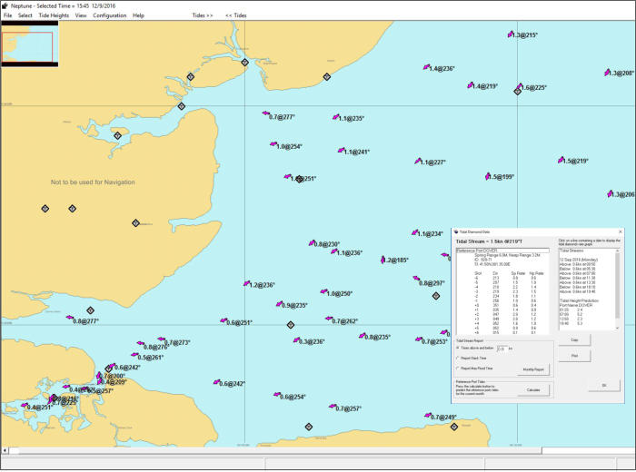
The Neptune tidal stream program provides tidal heights and a dynamic tidal stream atlas. Choose your date with a couple of mouse clicks
then step through half-hour at a time. The atlas instantly updates to give you a quick overview of tidal patterns as they change. Set and drift
figures are displayed for every tidal diamond, together with stream arrows.
This comprehensive software offers animated Tidal Heights and Tidal Streams using Outline cartography. The software incorporating Neptune's
Tidal Heights program. Configurable options for Tidal Stream colours and size, also displays tidal Stream reports. Touch screen or mouse
input. Data derived from UKHO sources. Tides and Tidal Streams program including
Program includes one portfolio of Outline charts £35.00
Additional Chart Portfolio £19.00
System requirements:
Recommended - Windows 8 and 10

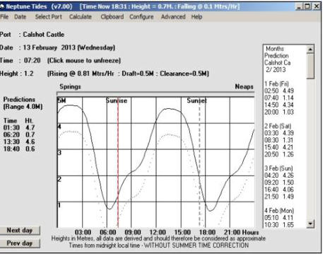
UK & European Tides
+ Instantaneous Tidal Predictions
+ Calculates Tables and Curves
+ No Annual Updates Required
+ Daily and Monthly Tide Tables
+ Tidal Rate of the Rise and Fall
+ Neap to Springs Meter
+ Primary and Secondary Ports
+ Predictions Include Users Depth
+ Draft & Under Keel Clearance
+ Next & Previous Port Option
+ Sunrise and Sunset Indicator
+ Predictions to the year 2060AD
+ Lunar phases
+ Tide Roll Function
+ Data derived from UKHO sources
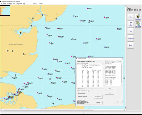
Tidal Streams
+ Outline Charts
+ Dynamic Tidal Stream
+ Tidal Stream Roll Function
+ Tidal Vectors
+ Configurable Displays
Tidal Heights & Tidal Streams
NEPTUNE Navigation Software +44(0)118 988 5309


Tidal Heights & Tidal Streams
UK & European Tides
+ Instantaneous Tidal Predictions
+ Calculates Tables and Curves
+ No Annual Updates Required
+ Daily and Monthly Tide Tables
+ Tidal Rate of the Rise and Fall
+ Neap to Springs Meter
+ Primary and Secondary Ports
+ Includes Users Depth
+ Draft & Under Keel Clearance
+ Next & Previous Port Option
+ Sunrise and Sunset Indicator
+ Predictions to the year 2060AD
+ Lunar phases
+ Tide Roll Function
+ Admiralty Licensed Data
Tidal Streams
+ Raster Charts
+ Dynamic Tidal Stream
+ Wind Grid
+ Tidal Stream Roll
+ Waypoint Editor
+ Tidal Vectors
+ Interfaces to GPS
+ Night Palette
+ Range Circles
+ Configurable Displays
+ Data derived from
UKHO sources
NEPTUNE Navigation Software +44(0)118 988 5309

Tides & Tidal Streams v10.3.3
The Neptune tidal stream program provides tidal heights
and a dynamic tidal stream atlas. Choose your date with
a couple of mouse clicks then step through half-hour at
a time. The atlas instantly updates to give you a quick
overview of tidal patterns as they change. Set and drift
figures are displayed for every tidal diamond, together
with stream arrows.
This comprehensive software offers animated Tidal
Heights and Tidal Streams using Outline cartography.
The software incorporating Neptune's Tidal Heights
program. Configurable options for Tidal Stream colours
and size, also displays tidal Stream reports. Touch screen
or mouse input. Data derived from UKHO sources.
Tides and Tidal Streams program including one portfolio
of Outline charts £35.00
Additional Chart Portfolio £19.00
System requirements:
Recommended - Windows 7, 8 and 10
Neptune Navigation Software Ltd
Unit 11 Diddenham Court
Lambswood Hill Grazeley RG7 1JQ
tel: +44 (0)118 988 5309