
Download Tides & Streams
Tides, Streams and Wrecks
Tides
Planner Plus
Outline Planner
C-Map Planner
Training
Site Map
Contact
Order
Home Page
Tides &
Tidal Streams
£44.95
Including one Charts Portfolios
Chart
Portfolio £20.00
each
Tides &
Tidal Streams
£130.00
Including the complete set of Charts Portfolios
Tides and Tidal Streams Software
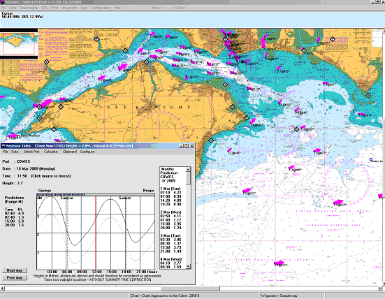
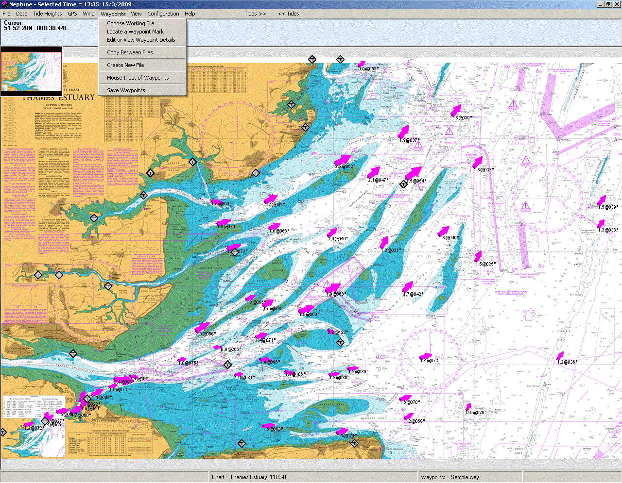
TIDES AND TIDAL STREAMS
The Neptune tidal stream program provides tidal heights and
a dynamic tidal stream atlas. Choose your date with a couple of mouse
clicks then step through half-hour at a time. The atlas instantly updates
to give you a quick overview of tidal patterns as they change. Set and
drift figures are displayed for every tidal diamond, together with stream
arrows.
This comprehensive software offers animated Tidal Heights and Tidal Streams using the Raster Chart cartography. The software incorporating Neptune's Tidal Heights program. Wind grid conditions and GPS position can be displayed, incorporating waypoint editor, configurable options Tidal Stream colours, size and shapes, screen brightness. The software uses UKHO data.
Tides and Tidal Streams
£24.95
The software requires
a Charts Portfolio
Additional Chart Portfolio
£20.00
Download Tides & Tidal
Streams Software
Tides & Tidal Streams Area
Portfolios
English Channel
Dover Straits & Thames
East Coast
Scilly Isles to N Wales
NW England & Irish Sea
West and North Scotland
Eastern Scotland
Ireland
|
|
English Channel |
|
|
2675-0 |
English Channel |
1:500,000 |
|
2655-0 |
English Channel - Western Entrance |
1:325,000 |
|
2656-0 |
English Channel Central Part |
1:320,000 |
|
2450-0 |
Anvil Point to Beachy Head |
1:150,000 |
|
2669-0 |
Channel Islands and Adjacent Coast of France |
1:150,000 |
|
2668-0 |
Ile Vierge to Plateau des Roches Douvres |
1:150,000 |
|
2644-0 |
Ile dOuessant to Ile de Batz |
1:150,000 |
|
2613-0 |
Cap de la Hague to Fecamp |
1:150,000 |
|
2451-0 |
Newhaven to Dover and Cap d’Antifer to Cap Gris –Nez |
1:150,000 |
|
0536-0 |
Beachy Head to Dungeness |
1:75,000 |
|
2045-0 |
Outer Approaches to the Solent |
1:75,000 |
|
2036-0 |
The Solent and Southampton Water |
1:25,000 |
|
2175-0 |
Pool Bay |
1:20,000 |
|
2611-0 |
Poole Harbour and Approaches |
1:12,500 |
|
|
Dover and Thames Estuary to Netherlands |
|
|
1406-0 |
Dover and Calais to Orford Ness and Scheveningen |
1:250,000 |
|
2449-0 |
Dover Strait to Westschelde |
1:150,000 |
|
1610-0 |
Approaches to The Thames Estuary |
1:150,000 |
|
1183-0 |
Thames Estuary |
1:100,000 |
|
1408-0 |
Harwich and Rotterdam to Cromer and Terschelling |
1:300,000 |
|
2451-0 |
Newhaven to Dover and Cap d’Antifer to Cap Gris –Nez |
1:150,000 |
|
1185-0 |
River Thames Sea Reach |
1:25,000 |
|
1892-0 |
Dover Strait Western Part |
1:75,000 |
|
0323-0 |
Dover Strait Eastern Part |
1:75,000 |
|
|
Canvey to London Bridge |
1:25,000 |
|
|
East Coast |
|
|
1408-0 |
Harwich and Rotterdam to Cromer and Terschelling |
1:300,000 |
|
1191-0 |
River Tyne to Flamborough Head |
1:200,000 |
|
1192-0 |
Saint Abb’s Head to The River Tyne |
1:200,000 |
|
1190-0 |
Flamborough Head to Blakeney Point |
1:150,000 |
|
1503-0 |
Outer Dowsing to Smith Knoll |
1:150,000 |
|
1504-0 |
Cromer to Orford Ness |
1:150,000 |
|
|
Scilly Isles to North Wales |
|
|
1121-0 |
Irish Sea with St Georges Channel and North Channel |
1:500,000 |
|
1123-0 |
App to St Georges Channel and Bristol Channel |
1:500,000 |
|
1410-0 |
Saint George’s Channel |
1:200,000 |
|
1410-0 |
Saint Georges Channel |
1:200,000 |
|
1178-0 |
Approaches to the Bristol Channel |
1:200,000 |
|
2565-0 |
Saint Agnes Head to Dodman Point including The Isles of Scilly |
1:150,000 |
|
1179-0 |
Bristol Channel |
1:150,000 |
|
1977-0 |
Holyhead to Great Ormes Head |
1:75,000 |
|
1973-0 |
Cardigan Bay Southern Part |
1:75,000 |
|
1972-0 |
Cardigan Bay Central Part |
1:75,000 |
|
1971-0 |
Cardigan Bay Northern Part |
1:75,000 |
|
1970-0 |
Caernarfon Bay |
1:75,000 |
|
1165-0 |
Bristol Channel Worms Head to Watchet |
1:75,000 |
|
1164-0 |
Hartland Point to Ilfracombe including Lundy |
1:75,000 |
|
1156-0 |
Trevose Head to Hartland Point |
1:75,000 |
|
1149-0 |
Pendeen to Trevose Head |
1:75,000 |
|
1148-0 |
Isles of Scilly to Land’s End |
1:75,000 |
|
1176-0 |
Seven Estuary Steep Holm to Avonmouth |
1:40,000 |
|
2878-0 |
Approaches to Milford Haven |
1:25,000 |
|
|
NW England and Irish Sea |
|
|
1826-0 |
Irish Sea Eastern Part |
1:200,000 |
|
1320-0 |
Fleetwood to Douglas |
1:100,000 |
|
2094-0 |
Kirkcudbright to Mull of Galloway & Isle of Man |
1:100,000 |
|
1346-0 |
Solway Firth and Approaches |
1:100,000 |
|
1981-0 |
Approaches to Preston |
1:75,000 |
|
1978-0 |
Great Ormes Head to Liverpool |
1:75,000 |
|
1951-0 |
Approaches to Liverpool |
1:25,000 |
|
1953-0 |
Approaches to the River Dee |
1:25,000 |
|
2010-0 |
Morcambe Bay and Approaches |
1:50,000 |
|
2013-0 |
Saint Bees Head to Silloth |
1:50,000 |
|
3164-0 |
Barrow Harbour and Approaches |
1:12,000 |
|
|
West and North Scotland |
|
|
1127-0 |
Outer Approaches to Northern Channel |
1:500,000 |
|
2635-0 |
Scotland West Coast |
1:500,000 |
|
1119-0 |
Orkney and Shetland Islands Fair Isle Channel |
1:200,000 |
|
1954-0 |
Cape Wrath to Pentland Firth including The Orkney Islands |
1:200,000 |
|
1785-0 |
North Minch Northern Part |
1:100,000 |
|
1794-0 |
North Minch Southern Part |
1:100,000 |
|
2250-0 |
Orkney Islands Eastern Sheet |
1:75,000 |
|
2249-0 |
Orkney Islands Western Sheet |
1:75,000 |
|
3282-0 |
Shetland Islands North-East Sheet |
1:75,000 |
|
3281-0 |
Shetland Islands North–West Sheet |
1:75,000 |
|
3283-0 |
Shetland Islands South Sheet |
1:75,000 |
|
2171-0 |
Sound of Mull and Approaches |
1:75,000 |
|
2168-0 |
Appproaches to the Sound of Jura |
1:75,000 |
|
2126-0 |
Approaches to the Firth of Clyde |
1:75,000 |
|
2169-0 |
Approaches to the Firth of Lorn |
1:75,000 |
|
2131-0 |
Firth of Clyde and Loch Fyre |
1:75,000 |
|
2198-0 |
North Channel Southern Part |
1:75,000 |
|
2210-0 |
Approaches to Inner Sound |
1:50,000 |
|
2209-0 |
Inner Sound |
1:50,000 |
|
2208-0 |
Mallaig to Canna Harbour |
1:50,000 |
|
2207-0 |
Point of Ardnamurchan to the Sound of Sleat |
1:50,000 |
|
|
Eastern Scotland |
|
|
1409-0 |
Buckie to Arbroath |
1:200,000 |
|
1942-0 |
Fair Isle to Wick |
1:200,000 |
|
1407-0 |
Montrose to Berwick-upon-Tweed |
1:200,000 |
|
0115-0 |
Moray Firth |
1:200,000 |
|
1192-0 |
Saint Abb’s Heas to the River Tyne |
1:200,000 |
|
|
Ireland Northern, East and South Coasts |
|
|
1121-0 |
Irish Sea with St George's Channel and North Channel |
1:500,000 |
|
1411-0 |
Irish Sea Western Part |
1:200,000 |
|
2723-0 |
Western Approaches to the Northern Channel |
1:200,000 |
|
2424-0 |
Kenmare River to Cork Harbour |
1:150,000 |
|
2049-0 |
Old Head of Kinsale to Tuskar Rock |
1:150,000 |
|
1468-0 |
Arklow to the Skerries Islands |
1:100,000 |
|
1787-0 |
Carnsore Point to Wicklow Head |
1:100,000 |
|
0044-0 |
Nose of Howth to Ballyquintin Point |
1:100,000 |
|
2798-0 |
Lough Foyle to Sanda Island including Rathlin Island |
1:75,000 |
|
1415-0 |
Dublin Bay |
1:25,000 |
![]() Buy Online
Buy Online
or call us on
+44 (0)118 988 5309
![]() Buy
Online
Buy
Online
or call us on
+44 (0)118 988 5309
Tidal Heights
Instantaneous Tidal Predictions
Tidal Streams