
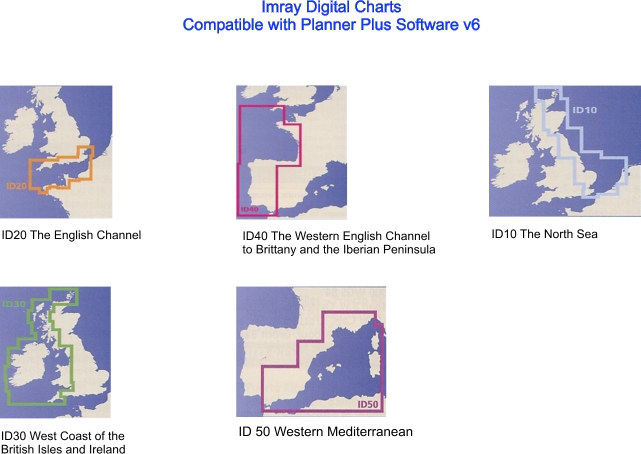
Plotter Planner Plus
RASTER CHART PORTFOLIOS
Tides, Streams & Wrecks
Site Map
Contact
Order
Home Page
English Channel & Channel
Islands
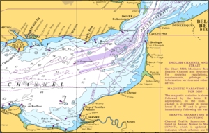
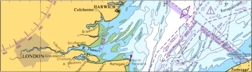
Dover Straits & Thames
East Coast
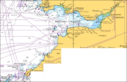
N Devon to South Wales
Wales
NW England
& Irish Sea
W Scotland and
Northern Island
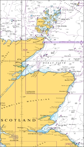
Eastern Scotland
Ireland
UKHO Raster Charts (Planner Plus and Tides, Streams and Wrecks)
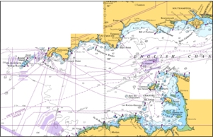
English Channel & Channel Islands
Dover Straits
& Thames
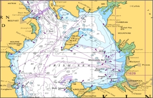
NW England
& Irish Sea
N Devon & Bristol Channel
Wales
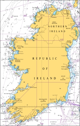
Ireland
East Coast
Eastern Scotland
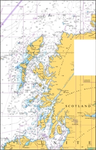
West and North Scotland
ENGLISH CHANNEL & CHANNEL ISLANDS
| Chart number | English Channel & Channel Islands | Scale |
|
2675-0 |
English Channel |
1:500,000 |
| 2649-0 | Western Approaches to the English Channel |
|
|
2655-0 |
English Channel - Western Entrance |
1:325,000 |
|
2656-0 |
English Channel Central Part |
1:320,000 |
|
0442-0 |
Lizard Point to Berry Head |
1:150,000 |
|
2454-0 |
Start Point to the Needles |
1:150,000 |
|
2565-0 |
Saint Agnes Head to Dodman Point including The Isles of Scilly |
1:150,000 |
| 2644-0 | Ile dOuessant to Ile de Batz |
|
| 2668-0 | Ile Vierge to Roches Douvres |
|
| 2669-0 | Channel Islands and Adj Coast of France |
|
| 2424-0 | Kenmare River and Cork Harbour |
|
|
2615-0 |
Bill of Portland to the Needles |
1:75,000 |
|
0777-0 |
Land’s End to Falmouth |
1:75,000 |
|
1148-0 |
Isles of Scilly to Land’s End |
1:75,000 |
|
1267-0 |
Falmouth to Plymouth |
1:75,000 |
|
1613-0 |
Eddystone Rock to Berry Head |
1:75,000 |
| 2045-0 | Outer Approaches to the Solent | 1:75,000 |
|
3315-0 |
Berry Head to Bill of Portland |
1:75,000 |
| 2615-0 | Bill of Portland to the Needles |
|
| 3653-0 | Guernsey to Alderney | 1:50.000 |
|
2610-0 |
Bill of Portland to Anvil Point |
1:40,000 |
|
0154-0 |
Approaches to Falmouth |
1:35,000 |
|
0154-1 |
Nare Head to Dodman Point |
1:35,000 |
| 2035-0 | Western Approaches to the Solent |
|
| 2037-0 | Eastern Approaches to the Solent |
|
| 2036-0 | Solent and Southampton Water |
|
|
1634-0 |
Start Point to Brixham |
1:25,000 |
|
1900-0 |
Whitand Bay to Yealm Head including Plymouth Sound |
1:25,000 |
|
1634-1 |
Salcombe to Start Point |
1:25,000 |
|
0032-2 |
Tresillian River |
1:20,000 |
|
0032-3 |
River Fal (Ruan Creek) |
1:20,000 |
|
0871-2 |
Calstock to Gunnislake |
1:20,000 |
|
0871-3 |
River Lynher |
1:20,000 |
|
0871-4 |
River Tavy |
1:20,000 |
|
2175-0 |
Pool Bay |
1:20,000 |
|
2255-0 |
Approaches Portland & Weymouth Harbour |
1:20,000 |
|
0031-2 |
River Fowey Saint Winnow to Lostwithiel |
1:15,000 |
|
0031-3 |
River Fowey Mixtow to Saint Winnow |
1:15,000 |
|
0147-5 |
Coverack Porthoustock Porthallow and The Mangles |
1:15,000 |
|
2345-5 |
Longship |
1:15,000 |
|
2345-6 |
Runnel Stone |
1:15,000 |
|
2345-9 |
Lizard Point |
1:15,000 |
|
0147-1 |
Helford River Continuation to Gweek |
1:12,500 |
|
2172-3 |
Worbarrow Bay |
1:12,500 |
|
0026-1 |
Tor Bay |
1:12,500 |
|
0028-0 |
Salcombe Harbour |
1:12,500 |
|
0030-0 |
Plymouth Sound and Approaches |
1:12,500 |
|
0030-1 |
Continuation of Hamoaze |
1:12,500 |
|
0032-1 |
Truro River |
1:12,500 |
|
0147-3 |
Helford River |
1:12,500 |
|
0147-4 |
East and West Looe Rivers |
1:12,500 |
|
0871-0 |
River Tamar Lynher and Tavy |
1:12,500 |
|
0871-1 |
River Tamar Cargreen to Calstock |
1:12,500 |
|
2172-1 |
Swanage and Studland Bays |
1:12,500 |
|
2172-2 |
Chapman’s Pool |
1:12,500 |
|
2253-3 |
Continuation to Totnes |
1:12,500 |
|
2253-2 |
Blackness Point to Berry Rock |
1:12,500 |
|
2290-0 |
River Exe and Approaches |
1:12,500 |
|
2290-1 |
Exeter |
1:12,500 |
|
2345-1 |
Penzance Bay |
1:12,500 |
|
2611-0 |
Poole Harbour and Approaches |
1:12,500 |
|
2611-1 |
Wareham |
1:12,500 |
|
2611-2 |
Holes Bay |
1:12,500 |
|
3315-1 |
Lyme Regis Harbour |
1:12,500 |
|
2268-0 |
Portland Harbour |
1:10,000 |
|
0026-2 |
Brixham Harbour |
1:7,500 |
|
0026-3 |
Teignmouth Harbour |
1:7,500 |
|
0031-4 |
Par Harbour |
1:7,500 |
|
1613-1 |
Eddystone Rock |
1:7,500 |
|
2172-4 |
Christchurch Harbour |
1:7,500 |
|
2172-5 |
River Stour |
1:7,500 |
|
0031-1 |
Fowey Harbour |
1:6,250 |
|
2253-0 |
Dartmouth Harbour |
1:6,250 |
|
2253-1 |
Continuation to Blackness Point |
1:6,250 |
|
0147-6 |
Looe |
1:5,000 |
|
0028-1 |
Salcombe |
1:5,000 |
|
0031-5 |
Charleston Harbour |
1:5,000 |
|
1902-0 |
Hamoaze |
1:5,000 |
|
1902-1 |
Ernesettle Pier |
1:5,000 |
|
2172-6 |
Weymouth Harbour |
1:5,000 |
|
2172-7 |
Lulworth Cover |
1:5,000 |
|
2268-1 |
Portland Port Berthing Plan |
1:5,000 |
|
2345-2 |
Mousehole Harbour |
1:5,000 |
|
2345-3 |
Newlyn Harbour |
1:5,000 |
|
2345-4 |
Penzance Harbour |
1:5,000 |
|
2345-7 |
Mullian Cove |
1:5,000 |
|
2345-8 |
Porthlevan |
1:5,000 |
|
3315-2 |
Bridport Harbour (West Bay) |
1:5,000 |
|
0026-4 |
Torquay Harbour |
1:4,000 |
| 2022-5 | Hillhead Harbour |
|
| 2021-8 | Isle of Wight Yarmouth Harbour |
|
| 2793-0 | Cowes Harbour and River Medina |
|
| 2793-1 | Continuation of River Medina |
|
| 2021-8 | Isle of Wight Yarmouth Harbour | 1:3,000 |
| 0147-2 |
|
1:2,500 |
|
0032-0 |
Falmouth |
1:1,250 |
|
2451-0 |
Newhaven to Dover and Cap d’Antifer to Cap Gris-Nez |
1:150.000 |
|
2450-0 |
Anvil Point to Beachy Head |
1:150,000 |
|
0536-0 |
Beachy Head to Dungeness |
1:75,000 |
|
1652-0 |
Selsey Bill to Beachy Head |
1:75,000 |
|
1892-0 |
Dover Strait Western Part |
1:75,000 |
|
1991-2 |
Littlehampton Harbour |
1:6,250 |
|
1991-3 |
Brighton Marina |
1:5,000 |
|
1991-4 |
Folkestone Harbour |
1:5,000 |
DOVER STRAIT AND THAMES ESTUARY
| Chart number | Dover Strait and Thames Estuary | Scale |
|
1408-0 |
Harwich and Rotterdam to Cromer and Terschelling |