Neptune Navigation Software Ltd
PO Box 5106 Riseley Berkshire RG7 1FD
sales@neptunenavigation.co.uk
tel: +44 (0)118 9885309
NEPTUNE Navigation Software +44(0)118 988 5309
Passage Planning app
Follow this link to the manual
See the introduction video on YouTube
Download the app from the Google Play Store to install on your phone or tablet
On your Android Mobile Phone or Tablet this app calculates the Course to Steer and the Optimised Departure Time from its built in tidal
database (you don't need to go on-line).
Neptune calculations are not time limited and you can passage plan and predict tides for now or for many years ahead as you wish.
With Route animations you can virtually sail your course to see the effect of wind over tides on your intended route. After a calculation you can
easily share your plans for SOLAS compliance.
Neptune uses raster charts derived from UKHO data, Imray charts or simple Outline chart and the latest chart can always be obtained by a
simple in-app download.
When you install the app you have a 5 day evaluation period which includes some sample data from the English Channel.
Neptune is primarily concerned with tidal passage planning in and around the UK and adjacent waters.
This app includes tidal height and time predictions for the UK and can also act as a Dynamic Tidal Stream atlas for it’s area. Chart coverage for
France, Spain, Portugal, The Mediterranean and Caribbean is also available using Imray charts, users should note tidal heights and streams are
not available in this app outside of the UK areas.
This app has very similar functionallity to our PC programs.


Program Features
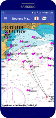
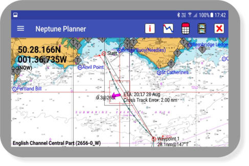
Course to Steer Calculations - Route Optimised Departure - Course over Ground - Dynamic Tidal Stream - Animate Routes - Tide &
Water Track Roll - Track Plotter - Waypoint Editor - SOLAS Compatibility - Course and Tidal Vectors - Cross Track Error displayed -
Interfaces to internal GPS - Tidal Stream - Incorporates Tides Program - Configure Displays - Tidal Data - Tidal Stream Reports and
Graphs - Insert Wind Values - Select Charts from server - Copy Screen and Route Buttons - GPX for Waypoint and Route - Import GRIB
with Weather displayed.
There is no charge for the app but the charts and associated tidal information requires a yearly subscription and the associated
royalties are paid by Neptune to the various issuing authorities.
Passage Planning app Free
Raster charts annually £24.49
Outline charts annually £18.49
Imray charts annually £34.95
System requirements:
Android 5.0 or later


Passage Planning app
NEPTUNE Navigation Software +44 (0)118 988 5309
NEPTUNE Navigation Software +44(0)118 988 5309

Passage Planner Planner app Currently Unavailable
With a subscription you can plan and calculate routes, predict
tides and streams, download GRIBS, produce tidal passage
plans around the UK.
On the Android Phone or Tablet Neptune calculates the
Course to Steer and the Optimised Departure Time from its
built in tidal database (you don't need to go on-line).
Neptune calculations are not time limited and you can
passage plan and predict tides for now or for many years
ahead as you wish.
With in-app download of UK charts you can easily obtain the
latest chart immediately prior to sailing.
Route animations enable you to virtually sail your plan to see
the effect of wind over tides on your intended route. After a
calculation you can easily share your plans for SOLAS
compliance.
Neptune is primarily concerned with tidal passage planning in
and around the UK and adjacent waters. This app includes
tidal height and time predictions for the UK and can also act
as a Dynamic Tidal Stream atlas for it’s area. Chart coverage
for France, Spain, Portugal, The Mediterranean and
Caribbean are also available using Imray charts, users should
note tidal heights and streams are not available in this app
outside of the UK areas.

Program Features
Course to Steer Calculations - Route Optimised Departure -
Course over Ground - Dynamic Tidal Stream - Animate Routes
- Tide & Water Track Roll - Track Plotter - Waypoint Editor -
SOLAS Compatibility - Course and Tidal Vectors - Cross Track
Error displayed - Interfaces to internal GPS - Tidal Stream -
Incorporates Tides Program - Range Circles - Configure
Displays - Tidal Data - Tidal Stream Reports and Graphs -
Insert Wind Values - Select Charts from server - Copy Screen
and Route Buttons - GPX for Waypoint and Route - Import
GRIB with Weather displayed.
Follow this link to the manual
See the introduction video on YouTube
Download the app from the Google Play Store to install on your
phone or tablet
There is no charge for the app but the charts and associated
tidal information requires a yearly subscription and the
associated royalties are paid by Neptune to the various
issuing authoritie
Passage Planning app Free
Raster charts annually £24.49
Outline charts annually £18.49
System requirements:
Android 5.0 or later
Neptune Navigation Software
Unit 11 Diddenham Court
Lambswood Hill Grazeley RG7 1JQ
tel: +44 (0)118 988 5309