Planner Plus including one
portfolio of charts
derived from UKHO sources
.
£95.00
Additional chart portfolios £29.00
Planner Plus including one Imray Portfolio of charts (ID20, ID10 ID30) £156.00
Additional Imray chart portfolio £90.00 each
Upgrade Planner Plus program to version 11.1.1 £25.00
Upgrade Raster Chart portfolio £15.00
Upgrade Imray Chart portfolio East Coast, The Channel and West Coast (ID10, ID20, ID30) £24.00 each
System requirements:
Recommended - Windows 8 and Windows 10, Windows 11
(Processor speed 1.6 GHz , Ram 2Gb, Typical HDD Space 300Mb)
Features of the new update to Planner Plus version 11.6.0
Download demo of Planner Plus version 11.6.0
Automatic chart change using Mouse scroll wheel
Waypoint and Route Management compatibility with modern GPX format (i.e. Garmin or Open CPN)
Waypoints and routes compatible with Neptune App.
UK Wrecks and Obstructions with details of depths, history, cargo etc
Bug fix in downloading some GRIB files
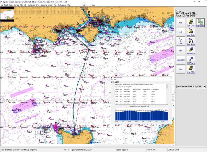
Program Features
Course to Steer Calculations - Route Optimised Departure - Course over Ground - Dynamic Tidal Stream - Wind & Polar Plot - Animate Routes - Tide & Water
Track Roll - Track Plotter - Waypoint Editor - SOLAS Compatibility - Course and Tidal Vectors - Cross Track Error displayed - Interfaces to GPS - Interfaces to
AIS Engine - Tidal Stream - Incorporates Tides Program - Range Circles - Configure Displays - Data derived from UKHO sources - Tidal Stream Reports and
Graphs - Grib Files for Internet Weather - Google Earth COG & Tracks - Select Charts using Thumbnails - Zoom to Rectangle - Copy Screen and Route
buttons - Snap to Waypoints - GPX for Waypoint and Route - Waypoint Transfer GPS Receivers & Plotters via NMEA 0183 - AIS Aid to Navigation Beacons -
Wrecks data.

NEPTUNE Navigation Software +44(0)118 988 5309
Tidal Passage Planning Software for the PC
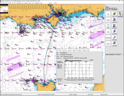
Passage Planning Software for the PC and Widows Tablet. This program is designed for tidal passage planning either on board or at home.
With its in-built tidal data for tidal streams and tidal heights this program calculates "Course to Steer" and the best time to go for tidal situations.
With its ability to import Wind GRIBs you can estimate your boat speed and produce passage plans very easily Animation enables you to virtually sail
the course and identify wind over tide situations.
This software also interfaces to GPS and AIS receivers via NMEA 0183 and so can function as a back-up plotter.
Version 11.0.0 is touch screen friendly and is useful for planning many years into the future.
Raster Charts
based on data
derived from
UKHO sources


Outline Charts
with tidal data
derived from
UKHO sources


Tidal Passage Planner Software
NEPTUNE Navigation Software +44 (0)118 988 5309
NEPTUNE Navigation Software +44(0)118 988 5309

Passage Planning Software is intended for tidal passage
planning either on board or at home on the PC.
With its in-built tidal data for tidal streams and tidal heights this
program calculates "Course to Steer" and the best time to go
for tidal situations.
With its ability to import Wind GRIBs you can estimate your
boat speed and produce passage plans very easily.
Animation enables you to virtually sail the course and identify
wind over tide situations.
This software also interfaces to GPS and AIS receivers via
NMEA 0183 and so can function as a back-up plotter.
Version 10 is touch screen friendly and is useful for planning
many years into the future.
Chart derived from UKHO data
Planner Plus including one
portfolio of charts
Charts derived from UKHO sources, £95.00
Additional chart portfolios £29.00 each
Upgrade Planner Plus program to version 11 £25.00
Upgrade Raster Chart portfolio £15.00 each
(If you require updates please telephone or e-mail Neptune)
System requirements:
Recommended - Microsoft Windows 11, 10, 7, or even XP
(Processor 1.6 GHz , Ram 2Gb, Typical HDD Space 300Mb)
Features for Planner Plus - PC version 11.6.0
Touch screen or mouse input
New menu layout
Ease of chart selection
UK Wrecks and Obstructions with details of depths,
history, cargo etc.
Program Features
Course to Steer Calculations - Route Optimised Departure -
Course over Ground - Dynamic Tidal Stream - Wind & Polar
Plot - Animate Routes - Tide & Water Track Roll - Track
Plotter - Waypoint Editor - SOLAS Compatibility - Course
and Tidal Vectors - Cross Track Error displayed - Interfaces
to GPS - Interfaces to AIS engine - Tidal Stream -
Incorporates Tides Program - Range Circles - Configure
Displays - Data derived from UKHO sources - Tidal Stream
Reports and Graphs - Grib Files for Internet Weather -
Google Earth COG & Tracks - Select Charts using
Thumbnails - Zoom to Rectangle - Copy Screen and Route -
Snap to Waypoints - GPX for Waypoint and Route -
Waypoint Transfer GPS Receivers & Plotters via NMEA
0183 - AIS Aid to Navigation Beacons - Wrecks data -
Neptune Navigation Software
Unit 11 Diddenham Court
Lambswood Hill Grazeley RG7 1JQ
tel: +44 (0)118 988 5309


Outline Charts